Miller Hull
- Portfolio
- Approach
- News
- About
- Connect
Designing Infrastructure as Architecture. Innovative, imaginative design proposals for new typologies of architectural infrastructure informed by rigorous research.
University of Washington Research Studio
Making the Invisible Visible: Designing Infrastructure as Architecture was a joint seminar and design research studio taught by Professor David Miller, Partner Scott Wolf, and part-time Lecturer Claire Shigekawa Rennhack during the Spring 2020 quarter for the College of Built Environments at the University of Washington. The two-part seminar and studio emphasized the importance of research and investigation of real world projects and future focused technology to inform the design proposals of innovative new typologies of infrastructural architecture. Infrastructure themes explored in this studio included water, energy, transportation and solid waste.
- Overview
This studio’s foundational belief is that Infrastructure and Utilitarian Architecture projects are an integral part of our urban environment and communities. No longer are these facilities out-of-sight and out-of-mind. There is an opportunity, and responsibility as architects, for us to make these facilities a much more visible, active, and engaging part of our built environment. Rather than try to buffer or screen them in the attempt to minimize their impact on their surroundings, a core goal of this studio was for students to realize the significant potential in celebrating infrastructure by making these projects even more visible.
Through research and design methods, students explored the potential of a more integrated approach with strong design concepts that frame infrastructure as public architecture. Students investigated issues of urban context, site analysis, landscape architecture design, sustainability and resiliency, state-of-the -art infrastructure technologies and the architectural design of an infrastructural facility. Challenging the students to envision what the infrastructure problem might become, this course also required students to design buildings that fulfill the complex functional requirements of a diversity of occupants present and future, while addressing environmental, structural and tectonic issues.
Research topics presented in seminar became the basis for the students’ studio design projects. Within the four primary infrastructural sectors of Water and Wastewater, Solid Waste, Energy and Transportation, students explored a diverse range of specific subjects within fields that they found particular interest. Students created their own research, proposals and design programs. Design projects varied from reimagining existing park and ride infrastructure as a new multimodal transit community hub, waste to energy plants that plan their own de-commisioning in 100 years time, to a patchwork system of micro water treatment plants that provide agricultural irrigation in rural areas. A few of these projects are highlighted in the sections below.
- Water - Sound Water by Katherine Acheson-Snow and Jesse Davis
A water infrastructure proposal by Katherine Acheson-Snow and Jesse Davis
As cities continue to respond to growing populations and the impact of human life on natural ecosystems, special attention to caring for our waterways elevates to a place of necessity – not just for our own water security, but for our planet as well. As climate change threatens water scarcity in our cities, it also threatens the natural water systems that begin in our mountains. Aquifers in the mountains that rely on heavy snowpack and rainfall are at critical levels, reducing the health of our region’s ecosystems through drought, forest fires, and increasing drinking water scarcity. Infrastructure to replenish these at-risk systems is a must.
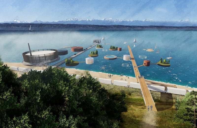
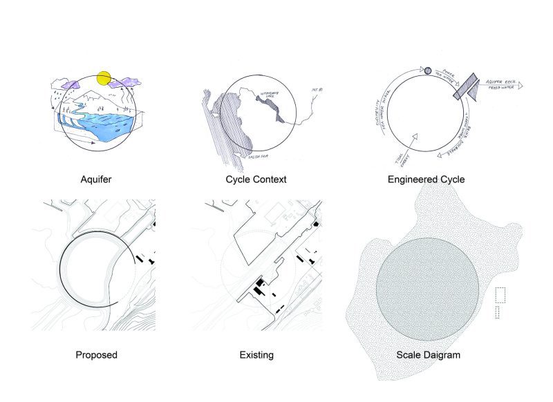 Looking forward, we will need to geoengineer the transfer of seawater to mountain ranges to replenish critical natural water infrastructure, while also preparing for rising sea levels. In light of this reality, we are proposing a desalination plant, tidal lagoon, and marine energy research facility that incorporates elements of education and play to connect the city of Bellingham and the region to this vital water cycle.
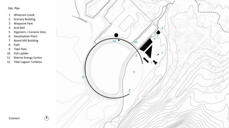
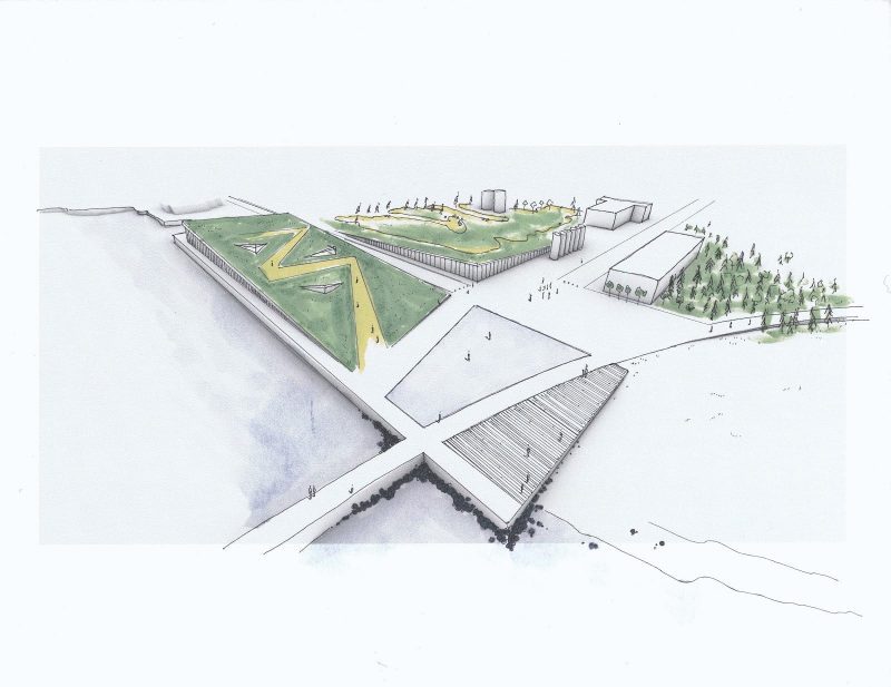
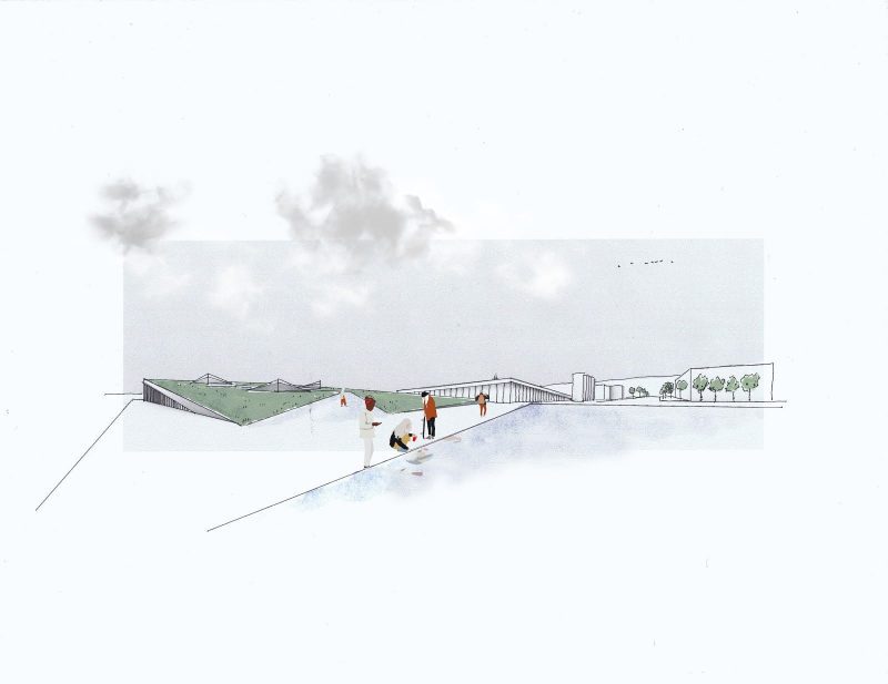
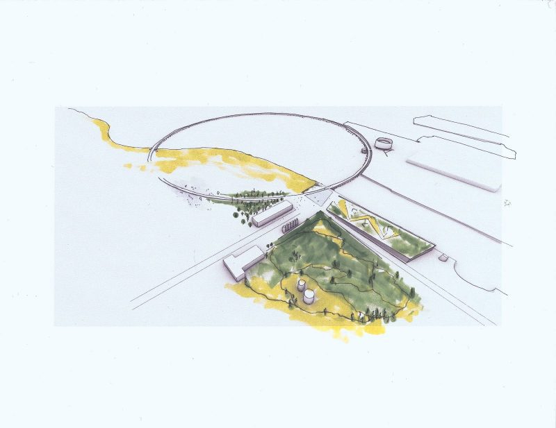
 The Path
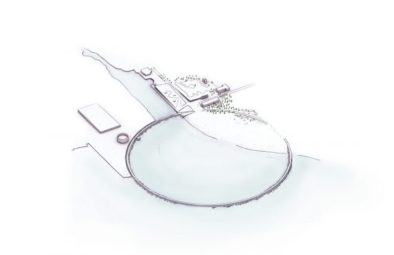
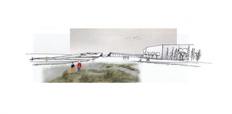
The Tidal Lagoon is placed into the waterfront to capture the natural freshwater outflow from Whatcom creek and provide a barrier to sea-level rise, creating a controlled waterscape for the public to enjoy. The former natural coastline is restored, creating opportunities for experiencing the natural journey of water from the mountains to the sea. The entire length of the tidal lagoon is occupiable, measuring 1.5 miles, and takes visitors through several vistas and environs.
Beginning with the entry plaza, visitors move through a forested grove, a reconstructed coastal wetland, a beach, out over the bay, alongside the ME Center and Fish Ladder, finishing again at the entry plaza and Desalination plant.
 Plaza
Plaza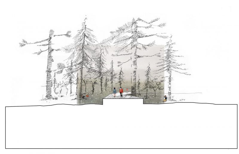 Forest
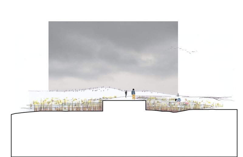 Wetland
 Beach and Tidal Flats
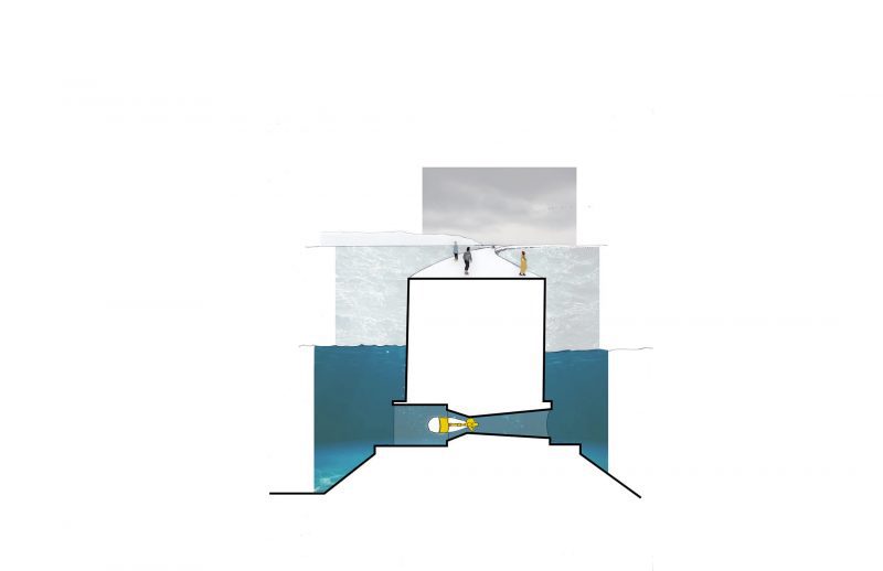 Lagoon Turbines
  Marine Energy
 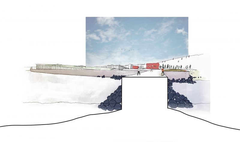 Desalination Plant
Desalination Plant
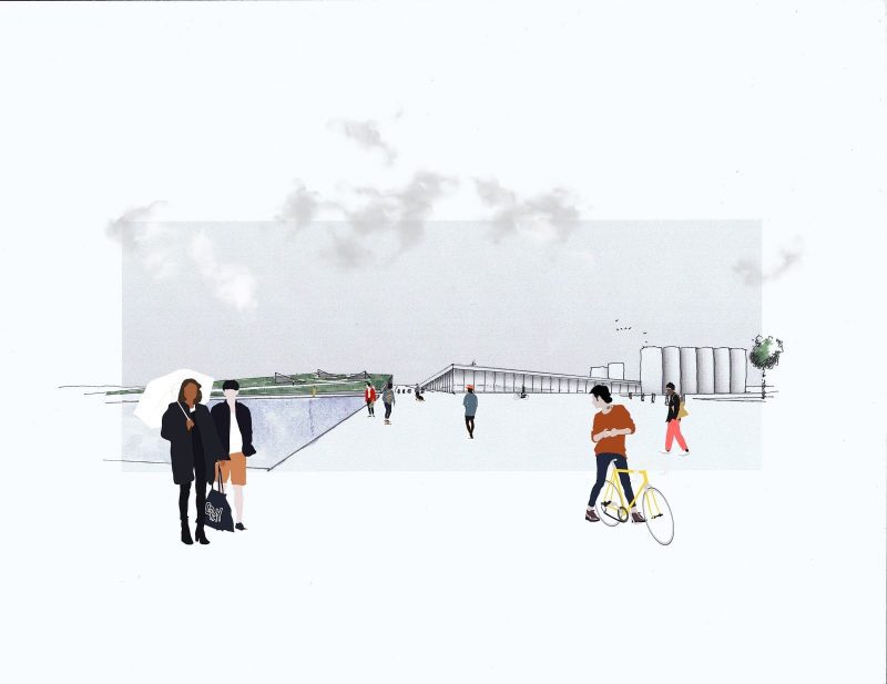
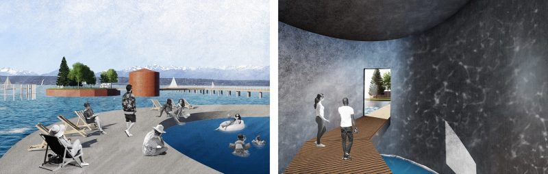
The former Boardmill building is retrofitted into a recreation and office facility, serving both the desalination plant and the ring where bike, paddleboard, and kayak rentals are available for use within the lagoon. Artifacts from the pulp mill are left in place. Seawater holding tanks are placed underground, expressed above by a thin reflection pool. Saltwater is treated and processed into freshwater on the northwest side and travels across the street to post-processing and freshwater holding tanks before being pumped to the mountains.
The Desalination Plant and Plaza
An occupiable path takes visitors above the desalination plant with viewports inside and vistas outward across the bay. On the northeast side, a mountain bike trail incorporates former site artifacts and the post-processing/pump facility into a continuous landscape. The reflection pool and boardwalk lookout frame the tidal lagoon path and entry plaza, which anchors the desalination facility to the ring. Together these elements express the critical work of recharging aquifers in the region while providing spaces for play, education, and connection.
A view from the plaza towards the Desalination Plant
A view from the path
A view into the Desalination Plant
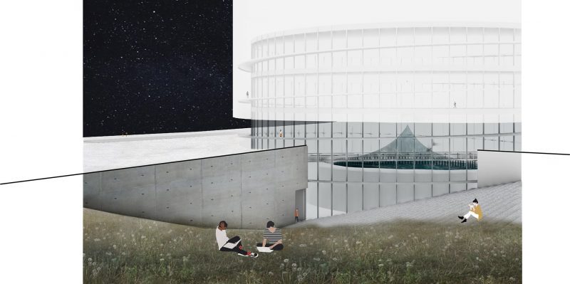
Aerial Perspective of the Desalination Plant, Path and Marine Energy Center
Marine Energy Center
Bellingham’s marine generation is currently low to nonexistent, however, with roughly 15-foot tides there is uncaptured potential specifically at the mouth of Whatcom waterway. This proposal incorporates a marine energy center which will have a research and education component for the surrounding Bellingham area, as well as larger organizations such as Pacific Marine Energy Center. This is intended to provide a central point and a space for dedicated marine energy generation research.
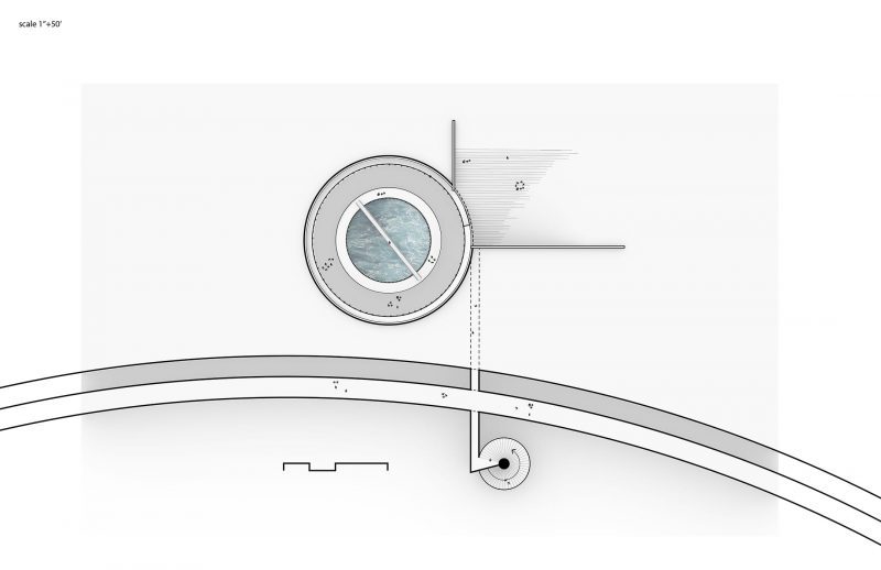
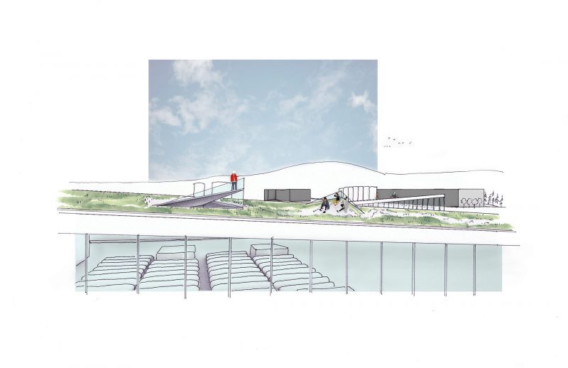
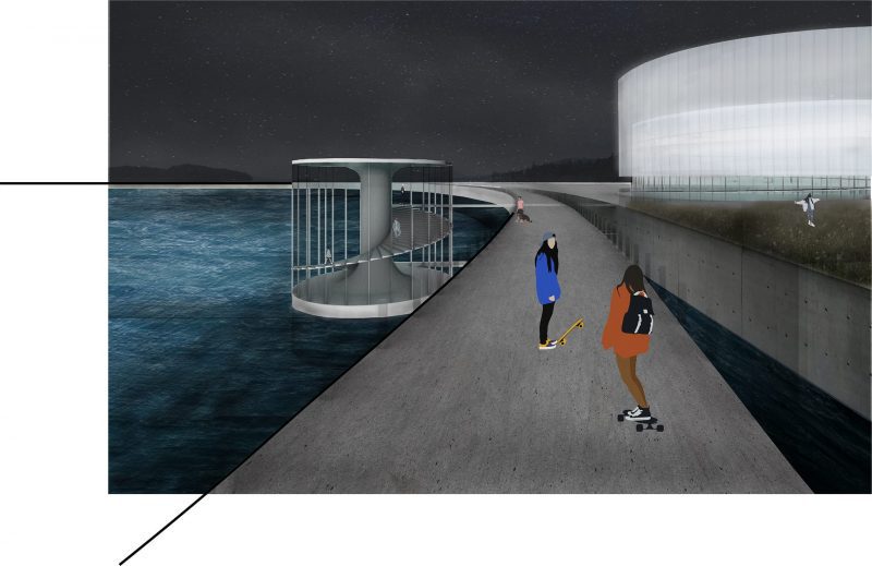
The Marine Energy Center and Occupiable Stair transect the path
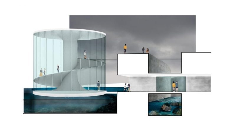
The large cylinder houses the educational program and research below with a large flow tank for wave generation. Tangential to the large cylinder is a smaller cylinder which provides an opportunity for observation of the flowing tides and the tidal lagoon infrastructure. A tunnel, which doubles as a bridge, connects the tidal lagoon to the existing constructed shoreline. Visitors can observe the fish ladder as they pass through or above the tunnel. The east portal opens to a terraced landscaped amphitheater, a space for gathering. The cylindrical masses provide structural stability amongst the ebb and flow.
Fish Ladder Section
 Approach
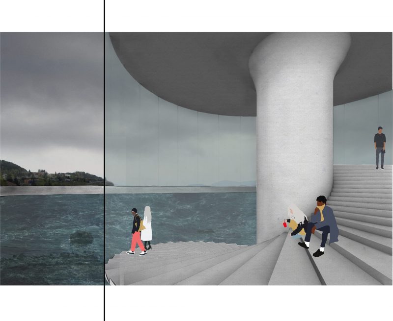 Occupiable Stair
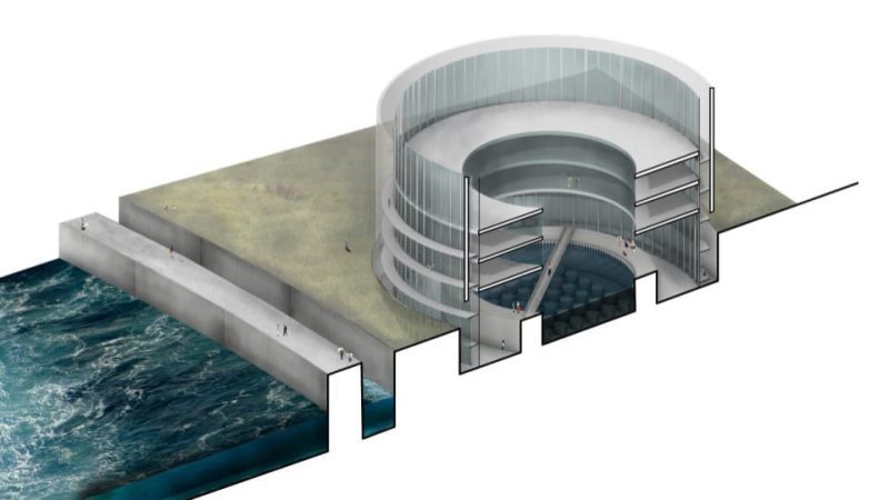
Section Perspective through Marine Energy Center
Grass Terraced Stairs
In conclusion, Global warming, sea-level rise, and each devastating product of climate change are reinforcing an urgent need for investment in renewable energy sources. Global targets for climate change have driven policy forward to decrease carbon emissions and increase investment in renewable resources. This studio project illustrates the exciting and actively evolving future of Marine Energy in conjunction with Desalination technology. Puget Sound is the second-largest estuary within the United States, and this project seeks to achieve a dual purpose of creating a resilient coastline and restoring natural water systems.
- Solid Waste - Trash Islands: Reclaiming Industrial Silos for the Future by Alissa Tucker
A solid waste infrastructure proposal by Alissa Tucker
When reflecting on how waste exists in the world today, the most impactful scenes are those of floating trash islands and overflowing landfills. This project seeks to turn waste into a resource through a Waste-to-Energy Plant that alleviates the need for long haul transport and permanent waste storage.
102 tons is the trash legacy each person is expected to produce in their lifetime. The magnitude of waste we generate is hard to fathom, but with urban population only expected to grow, it is critical that we evaluate how to make improvements to our current waste management practices. Seattle’s Climate Action Plan includes goals of diverting more waste into recycling and composting in the coming decades, but currently all waste is transported over 300 miles to a landfill in Oregon. The transportation of waste contributes to the enormous environmental impact of waste.
This proposal re-imagines the current system by introducing a local Waste-to-Energy plant that reduces transportation demands, while also creating energy for communities. The site of Point Wells was selected for its proximity to the city and access to barge and rail lines.
How can waste processing and public recreation productively coexist in the same space and time?
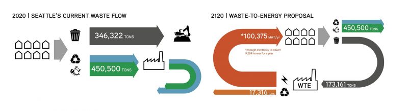
Seattle’s current waste flow directs nearly half of the city’s waste into landfills, and the rest is diverted to recycling and composting. The city’s Climate Action Plan calls for initiatives to divert more waste and the goal is that only a quarter of the waste needs to go into landfills.
What if Seattle takes it a step farther and redefines waste as a resource to close the conventional waste cycle?
The non-divertible waste could go into a Waste-to-Energy plant to create energy for the community, rather than needing to be permanently store in a landfill.
SITE | Point Wells
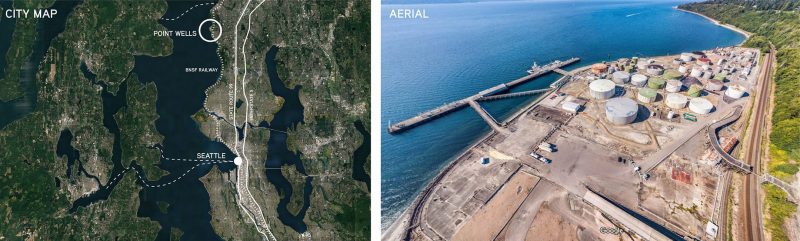
Waterways are a defining feature of Seattle. For centuries, humans have occupied its shores and depended on it for trade and resources. Waterfront developments foster economic growth and serve as crucial connectors between land and water. Point Wells is an example of this and the aerial photograph illustrates the current state of the site. It has had many lives as a filling station, petroleum storage, and an asphalt plant.
Point Wells occupies the shore to leverage transportation access to the water, but it must adapt to rising sea levels. How can this low-lying land and infrastructure be reclaimed for public good with sea level rise in 100 years? This proposal assumes an extreme sea level rise of 10 feet in the next century and about half of the existing silos are preserved for adaptive reuse.
TRASH ISLANDS
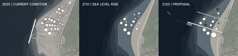
New pier structures are added to enhance connection from land-based arrival by train and water-based arrival by barge. These are the main circulation paths that stitch together water and land. Existing silos are transformed into waste storage, public space, and environmental assets. Some islands are accessible by the piers, while others are only accessible by boat. These adaptive reuse silos become places to gather and stake claim to. Public floats are new, flexible, floating islands that expand the original site boundaries. The Waste-to-Energy Plant is added to the site, and is home to infrastructure that processes incoming waste.
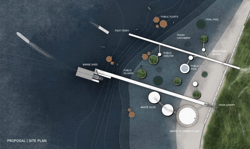
PIER | Utility Elements
While the project seeks to educate the public on waste management, there is a certain utility required for processing and moving waste as it arrives at the site. Separate piers allow a controlled, and safe environment for the public to access the educational components of the WTE Plant during specific hours.
 PIER | Public Elements
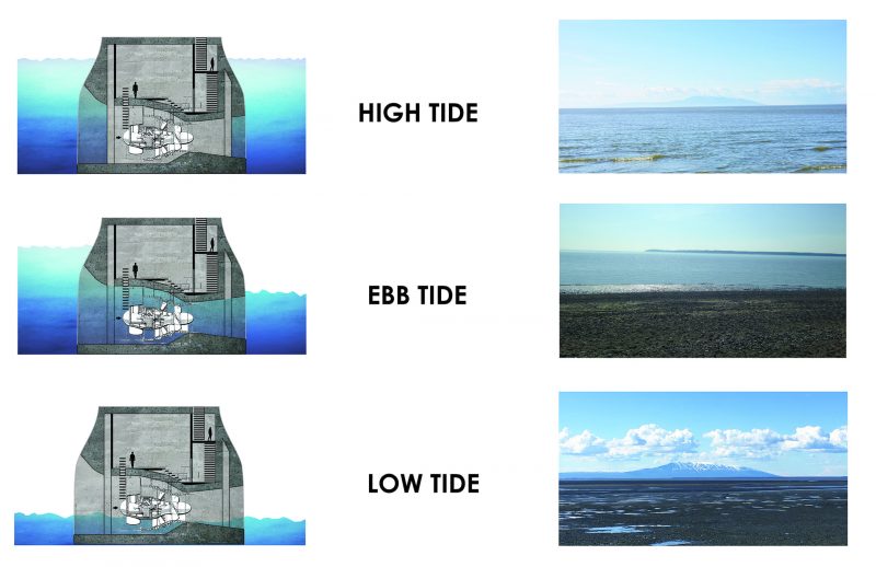
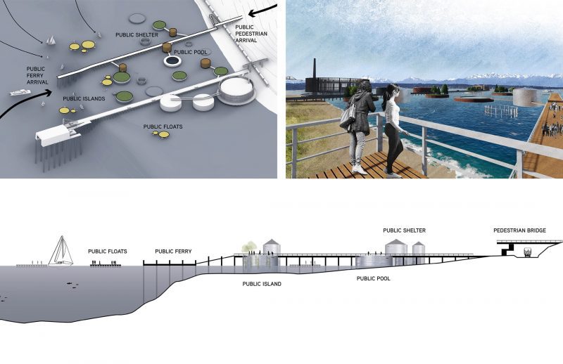 SITE EXPERIENCE | Low Tide
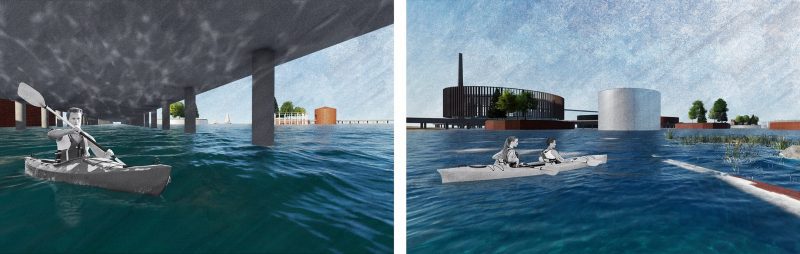
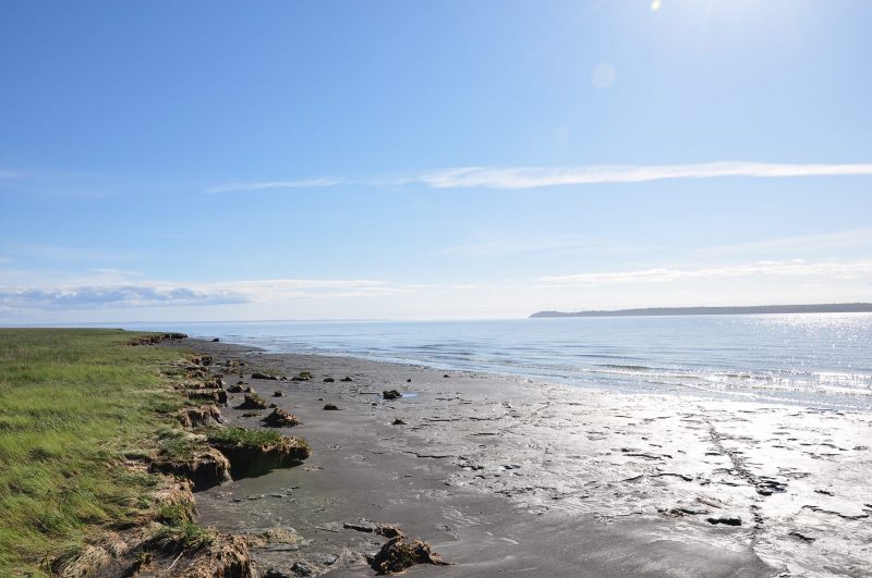
This proposal celebrates daily tidal ebbs and flows, and water’s changing relationship to architecture. Depending on when a visitor arrives during the tidal cycle, their experience will be different. At low tide, all silos are visible. The tidal pool silos create environments for fish to thrive and visitors to explore. Low tide also offers the opportunity to occupy space below infrastructure by foot, which gives a visitor a new perspective.

SITE EXPERIENCE | High Tide
At high tide, the tidal pools are fully submerged and hidden from view. The beach landscape is transformed into primarily water-based travel. There is allure to accessing floating islands or silos that are far removed from land. They become public spaces that friends can stake claim to for picnics and play. Visitors can still circulate underneath the pier structures to fully explore the site.
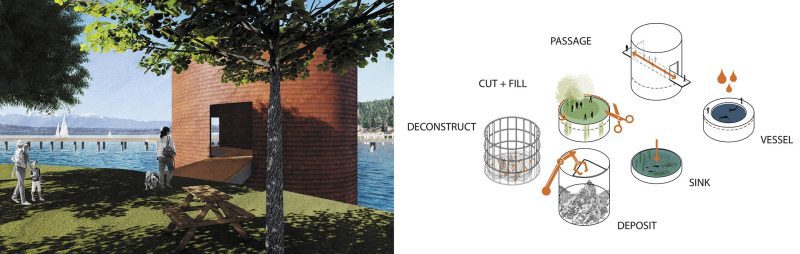
FIXED ELEMENTS | Adaptive Reuse Silos
A critical aspect of the project is the approach to the existing silo structures on site and how they can be adaptively reused to create space for the public. Roughly half of the existing silos are preserved for this proposal and each has had one of these typologies applied to it. Some silos are occupiable space for the public, while others offer environmental benefits.
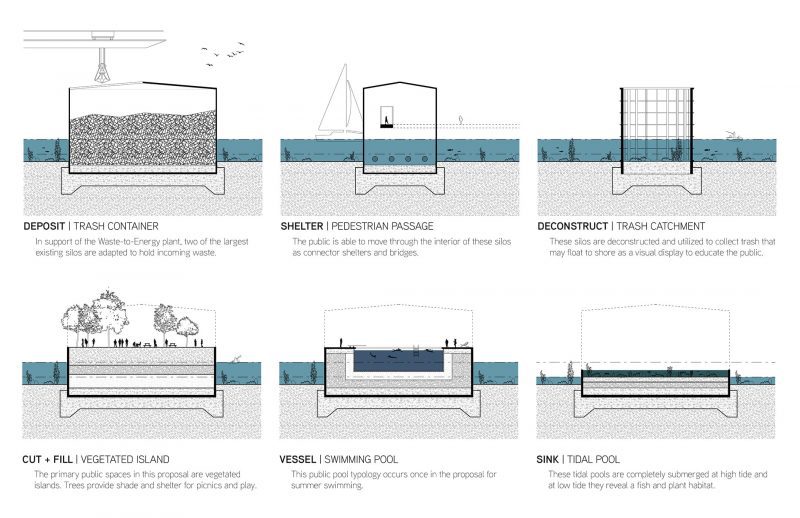
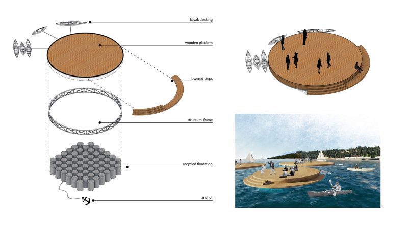
FLOATING ELEMENTS | Public Floats
With most of the architectural elements fixed on the site, it was important to create floating elements that maintain a direct connection to the water level at any point of the day. These public floats offer a space for people to dock their kayaks and enjoy the day on the water. They are built on recycled floatation elements to repurpose waste into a public amenity and redefine what is widely understood as a trash island.
 UTILITY ELEMENTS | Waste-to-Energy Plant
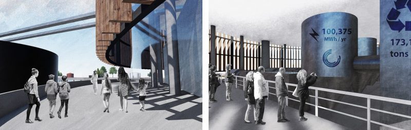
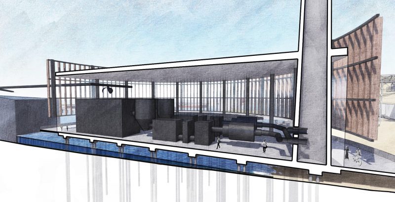
The functional heart of the project is the new Waste-to-Energy plant that responds to the existing forms on site and is a silo. It is clad in a wood screen to denote it as new construction compared to the adaptively reused silos, which are metal. Visitors are able to circulate around the perimeter and engage with the plant on interior viewing platforms. Adjacent to the plant are the large trash container silos. These allow the public to visualize the sheer volume of waste that comes out of the city every week before it is processed in the plant. Rather than waste being hidden out of sight and out of mind, it is made visible and the public can begin to understand the magnitude of the problem.
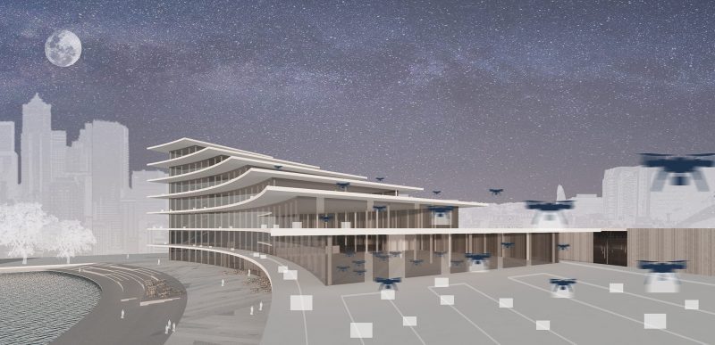
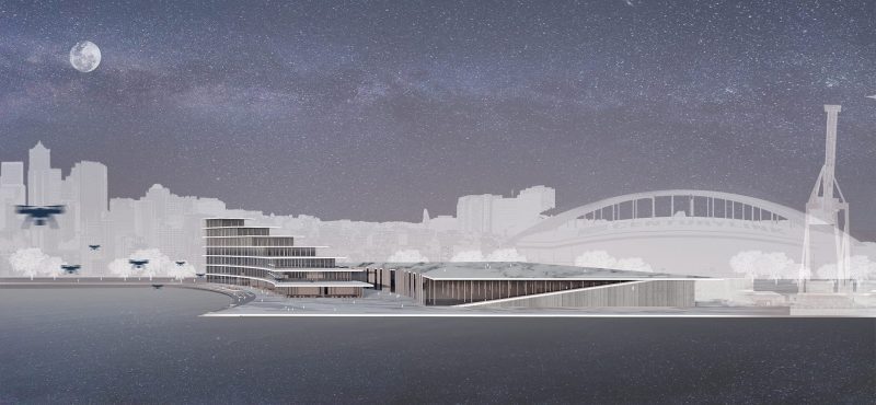
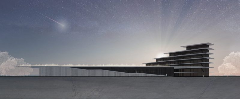
- Transportation - Droneport: Reimagining "Last Mile" Delivery by Gerte Urbon
A transportation infrastructure proposal by Gerte Urbon.
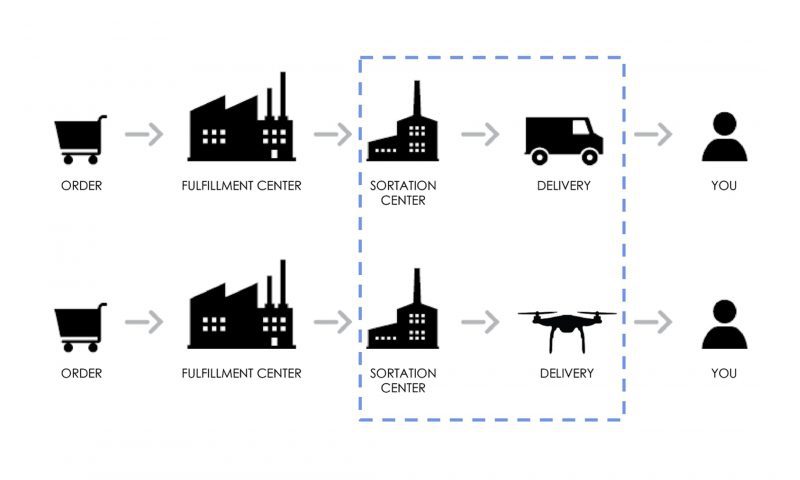
Seeing the potential of drones in the delivery services, such tech giants as Amazon, UPS and Alphabet are testing delivery drones for the “last mile” of the distribution process. Since the “last mile” distribution is the most expensive and time-consuming element in the shipping process, drone delivery can provide faster and more cost-effective solutions.
There are still many unanswered questions related to package delivery, safety, privacy, air traffic regulations, and so on. Nevertheless, once they are solved, we will see an emerging development in a new mode of goods’ transportation. Thus, a new typology would have to emerge, let’s call it a Droneport, that could accommodate these changes. Hence, the aim of this of this project is to explore the characteristics of the new architectural typology that could accommodate the emerging drone delivery in the future.
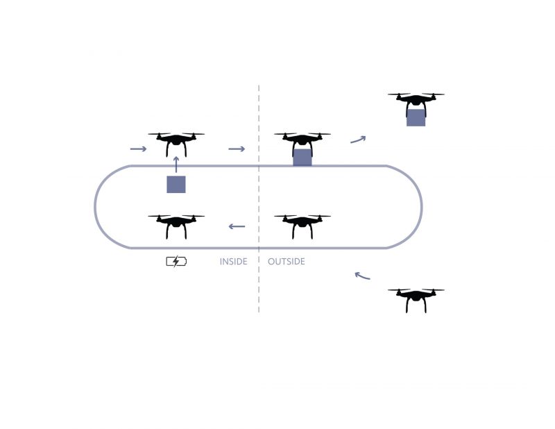
With the increasing use of drones, most of the changes would take place in two parts of the current delivery chain: sortation centers and delivery itself. This means that the currently existing or newly built sortation centers would have to accommodate the usage of drones: the take-off and landing platforms, new schemes of how packages move throughout the building, how they are prepared for the delivery and how they are transported by drones.
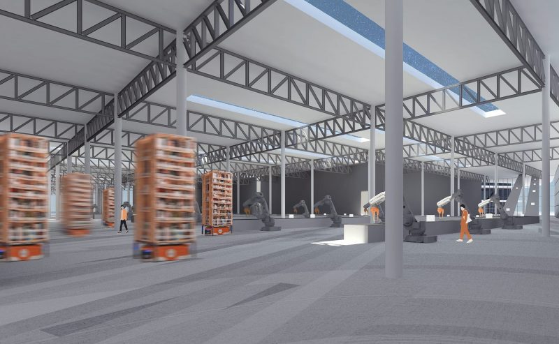
Amazon warehouse is a valuable case study for this project due to a wide range of robot implementation, from robotic arms to storage drive units. Out of 175 fulfillment centers worldwide, 26 of the warehouses are run by robots in assembling, transporting, or storing packages. Some Amazon warehouses in a way do not have a storage facility because products are randomly sorted into storage drive units and they are constantly moving around the facility. This allows the pickers to work stationary because the robots bring products directly to them. Therefore, the Droneport project implements such robotic scheme and adapts it to incorporate drone delivery.
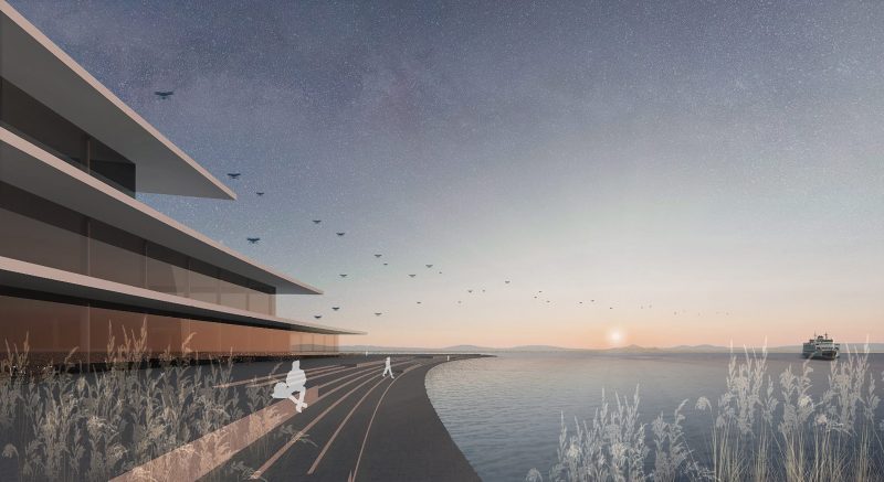
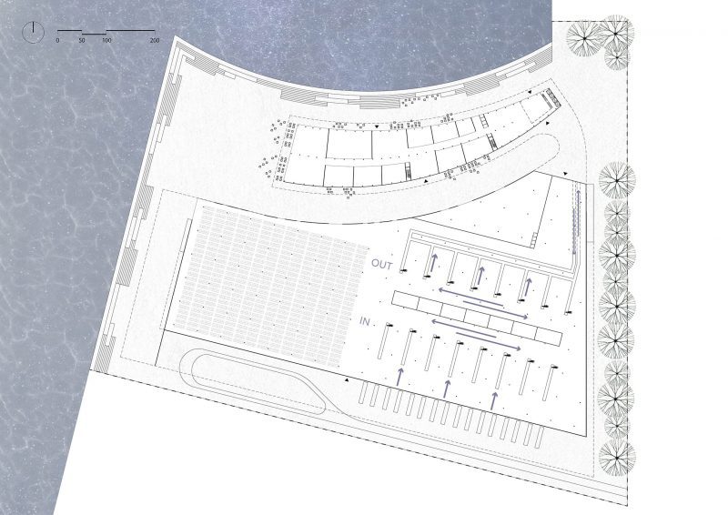
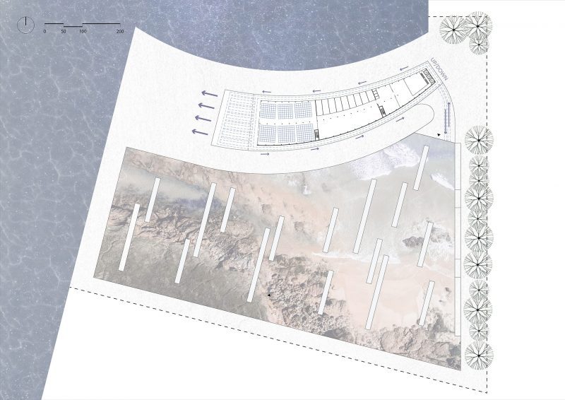
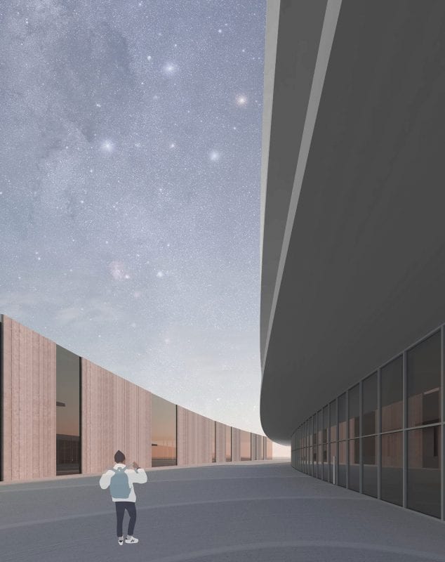
The site of this project is Pier 46 in Seattle, Washington. Location was selected due to proximity to the city and existing delivery infrastructure, as well as direct access to the water which provides possibilities for easier air traffic system. Since the site has close connection to the downtown, great attention is given to the public spaces. Thus, industrial environment is activated by designing numerous public plazas and providing access to the waterfront.

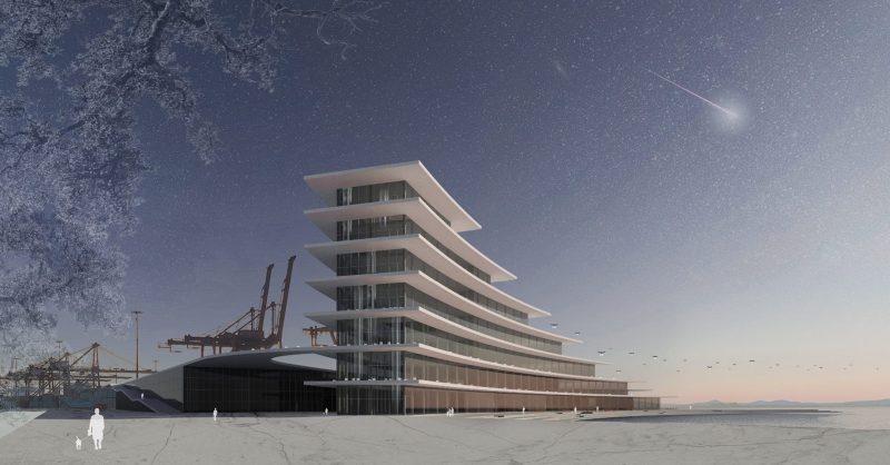
Project consists of two main parts: warehouse and Droneport. Warehouse is where the main scheme of the Amazon’s fulfillment centers is implemented. Here, items are assembled into a well-sealed and weatherproof packages and transported via conveyor belts from the warehouse to the Droneport.

Once the package reaches the Droneport, it is delivered to the necessary level by an elevator. From there, it is transported by the conveyor belts along the exterior of the building to an open-air platform, where it is fixed to the drone and then takes off.

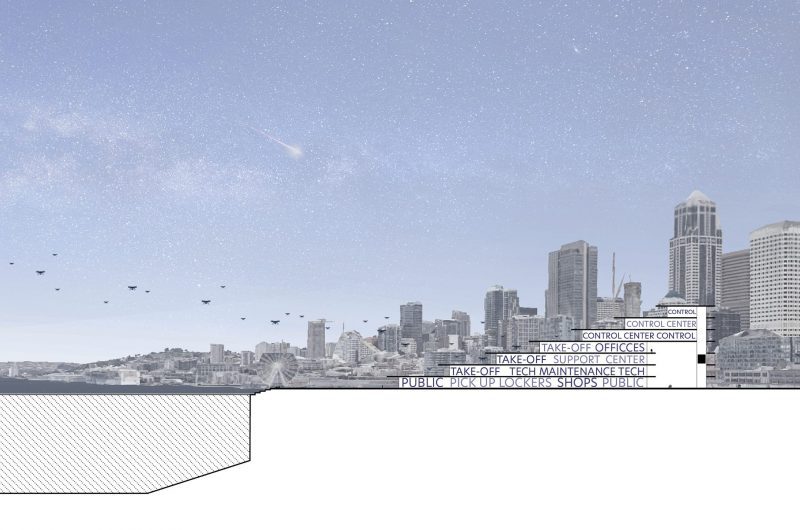
With the packages and drones moving along the exterior of the building the infrastructure becomes the main expression of this facility. As the core of the Droneport is dedicated to other supporting premises like offices, maintenance facilities, support center and public pick-up stations, delivery infrastructure becomes experiential and more approachable to all, from both inside and outside.
Creating public spaces was of great importance in this project. In addition to designing the waterfront access, the roof of the warehouse is turned into a park. With plants local to the coastal region like sea grasses and mosses, it returns the landscape to a place from which it was once eliminated by the industry.
While the goal of the project is to reimagine the delivery infrastructure, it also aims to reimagine our relationship to infrastructure itself. For this reason, sitting at the waterfront with drones taking off right above people’s heads becomes the key experience of the Droneport.
Autonomous robots have already been heavily applied at some warehouse facilities. Thus, introducing drones for the “last mile” delivery seems like a logical step for major companies in order to cut down the cost and time on the delivery process. For the delivery chain to reach the cost and time efficiency, Droneport typology should be developed together with the technology and not as an afterthought so that the technology and infrastructure could function as one intact system.
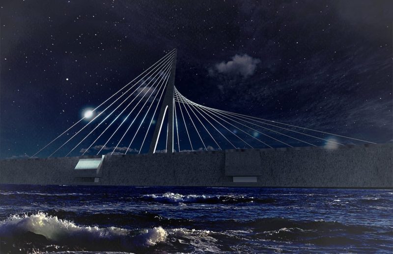
- Energy - Tidal Link by Lorryn Wilhelm
An energy infrastructure proposal by Lorryn Wilhelm
PROGRAM: Tidal energy facility, marine biology and energy research center, bike connection, Fire Island Native Cultural Center
SITE: Anchorage, AK, USA
PROJECT GOALS: Connect Anchorage to Fire Island near Kincaid Beach using a tidal barrage dam built to take advantage of existing wind power infrastructure. Diversify Anchorage’s energy portfolio and decrease fossil fuel dependency, encourage outdoor recreation, encourage education on energy, marine biology, and Dena’ina culture
Anchorage, Alaska has some of the largest tidal changes in the world–up to 35 feet. Correspondingly, Cook Inlet has some of the largest potential for tidal power generation on the planet. Tidal energy projects have been proposed for the Cook Inlet region before, but all have failed, primarily due to the abundance of cheap fossil fuel energy in Alaska. In the 21st century, however, it is imperative that Alaska embrace renewable resources to power its cities. Tidal Link reimagines how a tidal power station could become a public recreational and educational amenity for the city of Anchorage. The project balances cultural, ecological, and scientific concerns while creating renewable power and a space for all Anchorage residents to enjoy.
INFRASTRUCTURE | TIDAL ENERGY
Tidal energy is generated by taking advantage of the rise and fall of the tides to create a head—or a water level difference—between one side of a dam and the other. As the tide flows in, the basin behind the dam fills. Then the sluice gates are closed as the tide ebbs. When a large enough difference in water level has been created, the sluice gates are open and the water is released, powering a turbine to generate electricity.
Tidal energy is one of the youngest and least tested forms of renewable energy, with fewer than a dozen commercial scale facilities currently operating on the planet. However, it has great potential to transform the nature of renewable energy, especially in coastal areas of the globe.
SITE | ANCHORAGE, AK
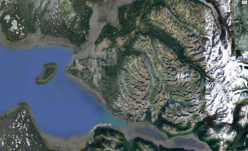
Tidal Link is sited along the western coastline of Anchorage. One of the reasons that a tidal energy station has never been realized in Cook Inlet is due to environmental concerns. The upper end of Cook Inlet is considered critical habitat for beluga whales and many species of salmon, and blocking an entire estuary would be detrimental to the health of these important species. Tidal Link addresses this concern by utilizing a shallow channel of water between Point Woronzof and Fire Island, a channel which is generally uninhabited by marine life due to the fact that it completely drains at low tide. At just over three miles, this channel is also one of the narrowest crossing points from the Anchorage coastline to any adjacent land.
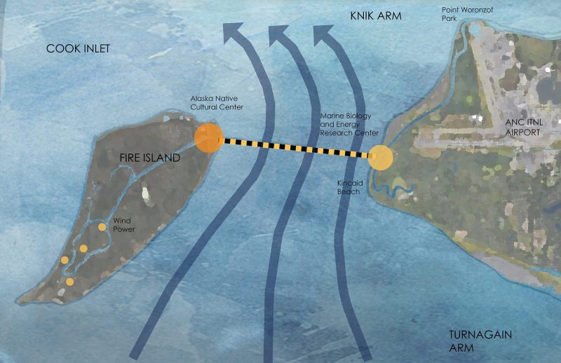
Constructing a tidal dam across this channel has the further advantage of being able to take advantage of pre-existing infrastructure. A buried conduit already connects Anchorage and Fire Island in order to transmit power from the Fire Island wind farm to the city of Anchorage. Fire Island, and the wind farm, are owned by CIRI Native Corporation. The north end of Fire Island is, in fact, a historic Dena’ina Alaska Native fishing area.
PROGRAM | PUBLIC INFRASTRUCTURE

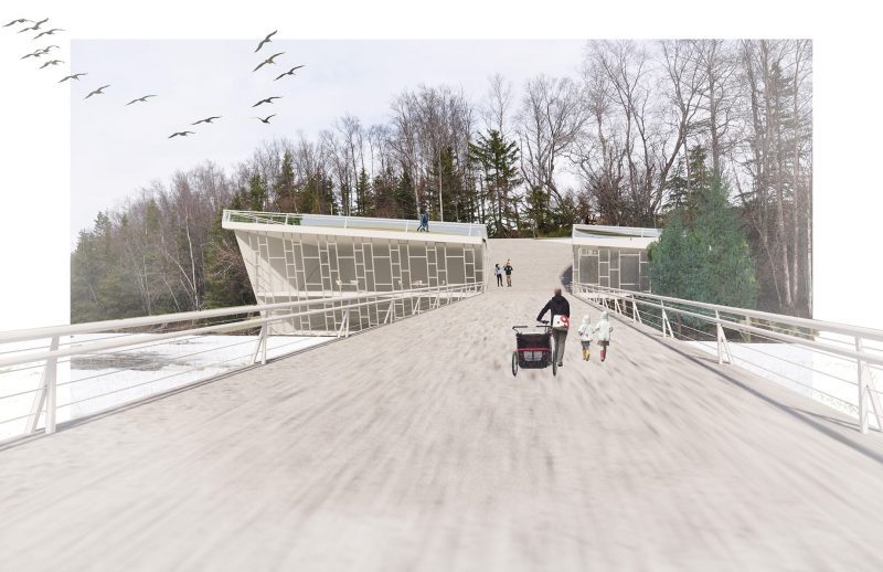
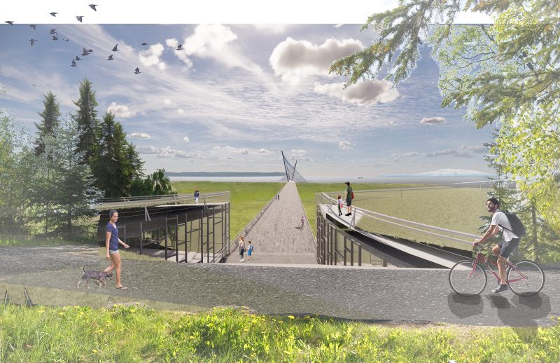
The presence of significant Dena’ina history on Fire Island, combined with the proximity of the Anchorage end of the dam with the wildly popular Coastal Trail gave birth to the idea of the tidal energy infrastructure as a public amenity and educational space. The Tidal Link dam is anchored on the Anchorage side by a Marine Sciences research and educational center, and on the Fire Island side by an Alaska Native Cultural Center, including a historic re-creation of a traditional Dena’ina fishing village managed by CIRI. The Tidal Link dam also provides a pedestrian and bike connection from Anchorage to Fire Island, opening up more than a dozen miles of trails that had previously been inaccessible for recreation.
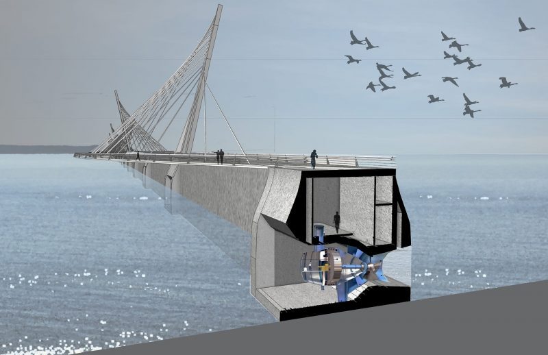
LINK | TIDAL ENERGY DAM
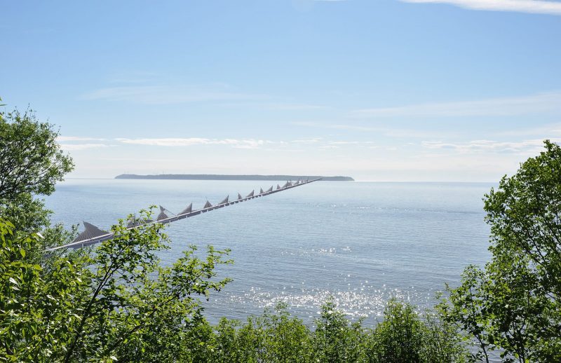
The energy infrastructure for the tidal energy dam, including the turbine houses for energy generation, follow the path of the existing wind farm electrical conduit across the channel from Anchorage to Fire Island. The accompanying pedestrian and bike path, however, is not bound to follow this straight-line path.

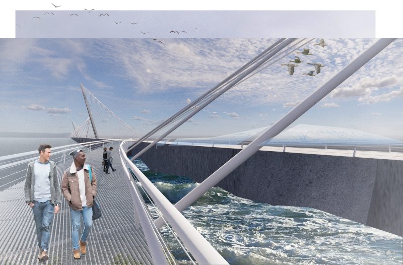
The bike path takes advantage of the solid structure of the turbine houses to cantilever over the water of the channel, arcing back and forth across the path of the dam. This allows visitors to experience the energy dam from both atop and beside. Translucent grating on the paths allows views to the water or channel floor below. Cables support the cantilevered path, and are tied back to canted columns on alternate sides of the bridge. The overall effect calls to mind the masts of a sailing ship, referencing Anchorage’s nautical past.
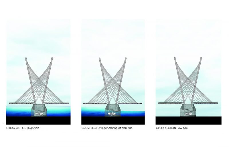
The dramatic tidal range in Anchorage means that at high tide, visitors will be less than ten feet above the level of the sea, whereas at low tide the drained floor of the channel will be almost forty feet below. This creates wildly different visitor experiences depending on the time of day.

ENTRY | MARINE RESEARCH CENTER
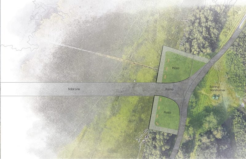
The Marine Research Center anchors the Tidal Link dam on the Anchorage. The site, set against steep bluffs, contains a stretch of the Coastal Trail along with transformers for the energy harvested from the Fire Island wind farm. The Marine Research Center is buried into the bluffs, creating an occupiable green roof that serves as a public plaza and rest area along the Coastal Trail. The two functions of the facility—public and private—are split by the descending ramp that leads from the Coastal Trail to the Tidal Link dam.
Acknowledgement
A special thanks to the following University of Washington Master of Architecture graduates who were a part of this studio:
Katherine Acheson-Snow, Elana Darnell, Jesse Davis, Arely Lopez Diaz, Jendy Edgerton, E.J. Elliot, Nolan Randall Higa, Jennifer Le, Steven Moehring, Nick Portman, Kyle Smith, Alissa Tucker, and Gerte Urbon